
Jomolhari Trek is longer than the Jomolhari Loop - the most popular trekking routes in Bhutan. With altitude differences of 2,500m and nearly 5,000m it offers a wide range of landscapes, fauna and flora. The highlight of this trek is the spectacular view of Mount Jomolhari from Jomolhari Basecamp (Jangothang).
Distance 40 minsTime 40 minsAscent descent 80mCamp Altitude 2,850m
This trek begins at Gunitsawa Village were you pass the army post. At the army checkpost your trek permit (provided your tour operator) will be checked and endorsed. The campsite is on the opposite side of the river, not far from Gunitsawa.
Distance 22 kmTime 7-8 hoursAscent Ascent 770 m, descent 10mCamp Altitude 3,610m
On this long day, the trail continues with lots of small ups and downs. After going uphill through the river valley the valley finally narrows gradually to a mere path which descends to a meadow where a camp will be set up. From here, if weather permits, you will have the first great view of Mt. Jomolhari.
Distance 19 kmTime 5-6 hoursAscent Ascent 480mCamp Altitude 4,080m
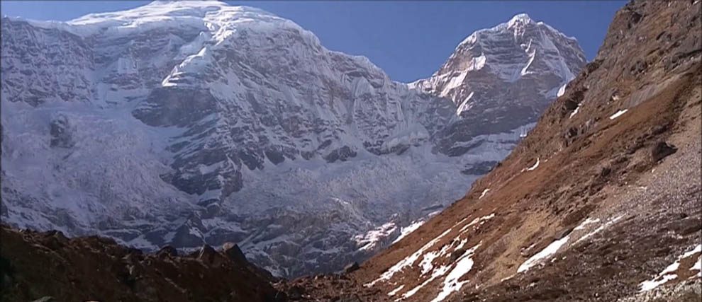
If you did not see Mt. Jomolhari the previous evening, you will still have a chance to get a great view early this morning. This morning the trek continues up the Paro Chhu valley which widens into patches of alpine meadow and scanty growths of forest. You will cross an army checkpoint along the way and enjoy a spectacular view of high mountain ridges and snow-capped peaks. In this area yaks and their herder’s homes become a regular feature of the landscape. Passing the villages Soe, Takethang and Dangochang is another asset on this day. After reaching Jangothang, one of the most beautiful campsites of the Himalayas, you will again have a spectacular view of Mount Jomolhari.
The rest day in Jangothang provides plenty of possibilities for day hikes with great views of lakes and snow capped mountains such as Jomolhari and Jichu Drake. There are good chances to spot some blue sheep on the upper slopes of the valley. Jangothang is a perfect environment for your acclimatization. You can also trek up to Tosoh or hike around the area. There are good short hiking trails in three directions. Jomolhari and its subsidiary mountain chains lie directly west, Jichu Drake to the north and there are a number of unclimbed peaks to the east.
Distance 16kmTime 6-7 hoursAscent Ascent 810 m, descent 1,090,mCamp Altitude 3,800m
The trail leads to a last settlement in the valley and drops to the Paro Chhu. Passing the lake of Tshophu (4,380m) you will climb up steeply to Bhonte La pass at 4,890 m, the highest point of this trek route. Reaching the Dhumzo Chhu river, you trek downstream passing the few houses of Soi Yaktsa (Dhumzo) to arrive at your camp soon after.